Південна Голландія
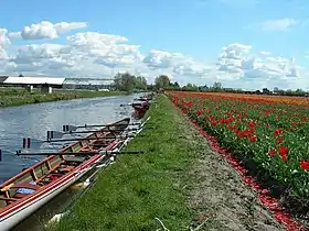
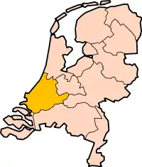
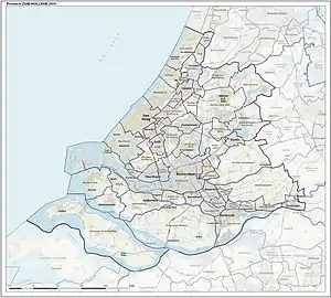
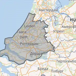
Південна Голландія (нід. Zuid-Holland) — провінція на заході Нідерландів, між Північним морем і дельтою річок Маас і Рейн. Провінція дуже урбанізована і є найзаселенішою в країні — на її території розташовані деякі найкрупніші агломерації Нідерландів: Роттердам, Гаага, Дордрехт і Лейден.
| Південна Голландія | ||||||||||
|---|---|---|---|---|---|---|---|---|---|---|
|
нід. Zuid-Holland | ||||||||||
| ||||||||||
 | ||||||||||
| Гімн: Aan jou o, Zuid-Holland, heb ik mijn hart verpand (Тобі, Південна Голландія, віддав я своє серце) | ||||||||||
| Столиця | Гаага | |||||||||
| Найбільше місто | Роттердам | |||||||||
| Країна | ||||||||||
| ||||||||||
| Номерний знак | H, HZ, HX | |||||||||
| Офіційна мова | нідерландська | |||||||||
| Населення | ||||||||||
| - повне | 3 458 875 осіб (2006) | |||||||||
| - густота | 1 227 осіб/км² | |||||||||
| Етнікон | нід. Zuid-Hollander, есп. sud-holandano і фриз. Súd-Hollanner | |||||||||
| Площа | ||||||||||
| - повна | 2 818 км² | |||||||||
| Часовий пояс | UTC+1 | |||||||||
| Дата заснування | 1840 | |||||||||
| Губернатор | Jaap Smitd | |||||||||
| Вебсайт | zuid-holland.nl | |||||||||
| Код ISO 3166-2 | NL-ZH | |||||||||
 | ||||||||||
| ||||||||||
 | ||||||||||

Найбільші міста
Міста з населенням понад 50 тисяч осіб:
| Назва міста | Населення, осіб (2009[2]) |
|---|---|
| Роттердам | 587134 |
| Гаага | 481864 |
| Зутермер | 120881 |
| Дордрехт | 118408 |
| Лейден | 116787 |
| Вестленд | 99436 |
| Делфт | 96517 |
| Східам | 75326 |
| Лейдсендам-Ворбург | 72697 |
| Спейкеніссе | 72521 |
| Алфен | 72178 |
| Гауда | 70828 |
| Влардінген | 70433 |
| Капелле | 65273 |
| Катвейк | 61337 |
| Лансінгерланд | 51019 |
Примітки
- archINFORM — 1994.
- Netherlands: Administrative Division (Provinces and Municipalities) - картографічний портал www.citypopulation.de (англ.)
Посилання
- Official site
- List of municipalities with population and area figures (hard to find on the site, because not under Gemeenten but under Over de provincie!)
- Basic information
- Lists of towns and villages, with municipality
- Province maps showing subdivision in municipalities:
- small version linking for each municipality to basic data page in Dutch (2006)
- gif (not up-to-date)
- pdf (map on page 6, higher resolution than the gif-map) (not up-to-date)
- Map of 1853
- Tourist information — The province is subdivided in eight regions, not corresponding to those above. The maps show villages, not municipalities.
- Tourist information for a region called Zuid-Holland Zuid (South Holland South), but different from the one in the previous section: less on the west, more on the east; it is the region called «Dutch river area» in the website of the previous link.
- https://web.archive.org/web/20051120143347/http://www.atlasgeo.ch/fotw/flags/nl-zh-.html — various info on the province and its municipalities, in particular flags
- Deltaworks Online — Flood protection of South Holland and Deltaregion
| Північне море | ||
| Північне море |  |
|
This article is issued from Wikipedia. The text is licensed under Creative Commons - Attribution - Sharealike. Additional terms may apply for the media files.